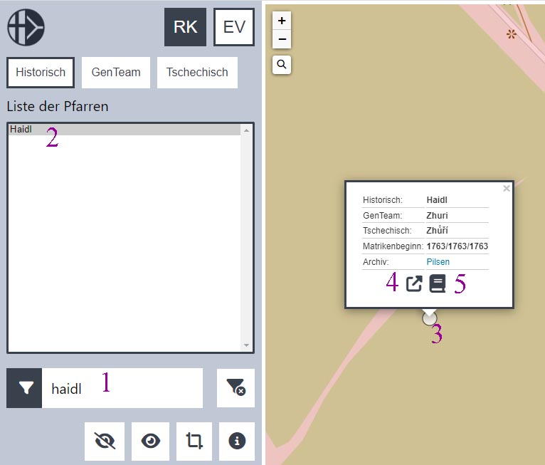
Parish finding tool for Bohemia and parts of the current Czech and Slovak republics
Go to https://pfarren-cz.oefr.at and follow the steps below, with numbers in the screen to help.
- Click on whether you are looking for a Roman Catholic parish or a protestant parish.
Then, enter the name of the village beside the funnel/filter icon, e.g. Haidl
- Click on the Haidl in the “Liste der Pfarren”.
Scroll and click on the "-" sign of the map if you want to see where this parish is located. - Click on the dot representing the village to get more information about the village.
- Click on the icon of an arrow inside a box to get a direct link to this map.
- Click on the book icon to see a website that leads to the parish church records whether online or at a European archive.
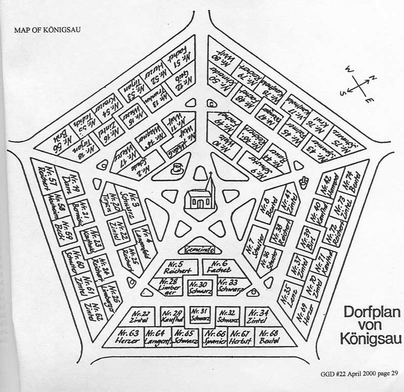
Königsau
Königsau in German:, Rowne in Polish; Rivne in Ukrainian SITE UNDER CONSTRUCTION
 |
Location and overview History Village map in 1939 Resident list from 1788 (Family Search) Königsau in Forgotten Galicia |
Location and overview
German settlement in the old Medenice manor in the Drohobycz district, 22 km north-east of Drohobycz and 6 km south-west of the district court and post office in Medenice. To the north lies Josefsberg, to the north-west Bilcze (Archduke Albrecht railway station). In the south-west lies Kawsko (to the district of Strij) and Letnia. Village buildings are arranged in the middle in a regular pentagon. In the center is a church. There is a free space around this. From this, 5 streets run in the direction of the corners.
Around the village are fields, meadows and pastures. Seen from the south-east, the height is 309 m, and from the east it is 305 m.
The river Niezachowka flows in the eastern part of the region with the influence of smaller streams. The smallest named Jastrzybna is on the border with Kawsko. Arable land includes 1296, meadows and gardens 58, pastures 15 acres (1 acre = 57.55 ares)
According to the description from 1880 there were 675 inhabitants (Roman Catholic). The Roman Catholic Parish is in place, the Greek-Catholic. in Letnia. The wooden church was built in 1848. Also a one-class school without a budget. The commune loan fund has a capital of 485 zlotys.
Bredetzky writes about this colony: (Historical contribution to the German colonial system in Europe, Brünn 1812) ... 80 houses with 400 inhabitants.
Excerpt from: "Geographical dictionary of the Polish kingdom and other Slavic countries", volume IV, letter Kes-Kut, year 1884, Editors: Filipa Sulimierskiego, Bronislawa Chlebowskiego and Wladyslawa Walewskiego
Sharing Our Heritage (SOH)
Surname/Village Database
THANK YOU for sharing your surname with us!
If you do not get confirmation that your surname has been added to our database within 1 week,
Contact ![]() for assistance.
for assistance.
To return to the Sharing our Heritage page click here.
To return to the Galizien German Descendants Home page click here
1950 USA Census
By Dave Gorz, GGD Treasurer
The National Archives and Records Administration (NARA) has released the 1950 US Census. The pages of the census were scanned and Optical Character Recognition (OCR) and artificial intelligence were used to try to interpret the names. OCR of handwriting is still in its infancy, for example one family found their surname "Gorz" in the index as "Dary". They only found the census information because they knew the street name.
Any group of records is tagged as to state, county, and city and also by Enumeration District (ED). For very large cities, such as Chicago, the number of ED’s is quite large.
If you know the address of the people you’re looking for, the ED within the city can be determined and that narrows down the search. This web site will help you determine the ED:
https://stevemorse.org/census/unified.html
Note that there is a drop down list at the very top of the web page where the year of the census can be set so make sure it is set for 1950.
There are drop down lists where you can enter the state, county and city and entering those three will give you a list of ED’s. If you enter Illinois, Cook, Chicago, you get hundreds of them. So the next step to narrow things down is to enter a house number and street name, if you know them. But there’s still more to go. If the street is quite long, there will by many ED’s associated with it, but you can continue to narrow things down by entering the cross streets at both ends of the block and/or entering a street that runs parallel to the street being searched. For small towns you’ll probably get only a few ED’s, so you may not need to enter the cross streets and searching should go quickly.
Many small towns do not show up in the list of towns/cities in a county but you’re given the option of selecting “Other” and entering a name. If that fails to give you ED’s, you may have to look at an Enumeration District map to find the number for your town. There is a link button for viewing the ED map for the state and county you’re searching.
After entering all the information you know for the location you’re searching, clicking on an ED number will take you to another page where you can select the viewer that you wish to use. The current choices are the NARA viewer, Family Search, and Ancestry; though right after the census was released the Ancestry viewer was not available. It appears that the Family Search and Ancestry viewer web sites are in the process of indexing the names, so it may take some time before they’re useable.
Make a note of the ED of interest because once you have that you can go directly to the NARA site and enter it along with the state and county and start searching again.
https://1950census.archives.gov/search/
Although they’re not quite ready to go, Ancestry and MyHeritage have a 1950 census web page.
https://www.ancestry.com/c/1950-census
https://blog.myheritage.com/2022/04/myheritage-publishes-the-1950-u-s-census-search-for-free/
Paper Based Maps and Map-related Books
Some of these resources are dated. Please refer to our maps page for online maps that are now of such good quality that paper maps are seldom ordered.
-
Historical Atlas of East Central Europe - by Paul Robert Magocsi. A History of East Central Europe, Univ. of Washington Press, Seattle, ISBN 0-295-97445-1. Can also be ordered through inter-library loan.
-
Sections, Townships and Ranges - Ray Hill. Article describing the grid system used in sections, townships and ranges. SGS Bulletin #29, #4, Dec 1998 page 135. to help you locate your ancestor's homestead in provinces of Alberta, Saskatchewan and Manitoba (Western Canada).
-
Galician Cadastre Maps - Land Surveys of 1849 and 1874 by John D. Pihach. Article in SGS Vol. 27 #1, March 1996, page 24-31. Cadastre maps are a collection of texts and maps that provide a snapshot of a community a century and a half ago. These maps can be found in the archives of Vienna, (Austria) Przemysl, (Poland), and Lviv (Ukraine) for those searching in Galicia. Article tells how to read the maps and other info.
-
Galician Cadastre Maps: Land Surveys of 1849 and 1874 - article by John Pihach. EEG June 1994, Vol. 2, #4, pages 16-24.
-
Josephinian Land Survey Maps "Josephinischen Landesaufnahme" at the War Archiv "Kriegsarchiv" in Vienna. Article by Brian Lenius. EEG Vol. 5#3, Spring 1997. Survey produced between 1760-80's shows roads, villages and other features as they were over 200 years ago. Commissioned by Empress Maria-Theresia and Emperor Joseph II and produced between 1764-1787. Pages 11-24.
-
Obtaining Galician Maps from Vienna's Kriegsarchiv - article by John Pihach. EEG March 1995, Vol. 3, #3. Includes address
-
Old World Maps Online has historical maps of the entire world. Many of them are online and can be downloaded, but some are paper based and must be ordered from the publisher. This site has an easy-to-use interface where you put a square around the area of interest and it lists all the available maps on the right hand side.