Königsau
Königsau in German:, Rowne in Polish; Rivne in Ukrainian SITE UNDER CONSTRUCTION
 |
Location and overview History Village map in 1939 Resident list from 1788 (Family Search) Königsau in Forgotten Galicia |
Location and overview
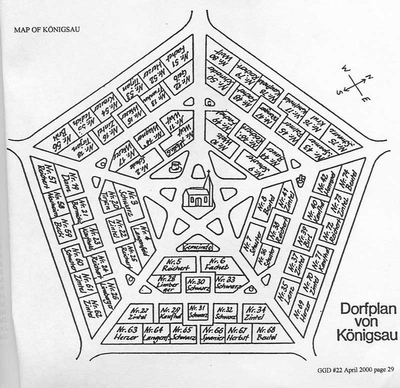
German settlement in the old Medenice manor in the Drohobycz district, 22 km north-east of Drohobycz and 6 km south-west of the district court and post office in Medenice. To the north lies Josefsberg, to the north-west Bilcze (Archduke Albrecht railway station). In the south-west lies Kawsko (to the district of Strij) and Letnia. Village buildings are arranged in the middle in a regular pentagon. In the center is a church. There is a free space around this. From this, 5 streets run in the direction of the corners.
Around the village are fields, meadows and pastures. Seen from the south-east, the height is 309 m, and from the east it is 305 m.
The river Niezachowka flows in the eastern part of the region with the influence of smaller streams. The smallest named Jastrzybna is on the border with Kawsko. Arable land includes 1296, meadows and gardens 58, pastures 15 acres (1 acre = 57.55 ares)
According to the description from 1880 there were 675 inhabitants (Roman Catholic). The Roman Catholic Parish is in place, the Greek-Catholic. in Letnia. The wooden church was built in 1848. Also a one-class school without a budget. The commune loan fund has a capital of 485 zlotys.
Bredetzky writes about this colony: (Historical contribution to the German colonial system in Europe, Brünn 1812) ... 80 houses with 400 inhabitants.
Excerpt from: "Geographical dictionary of the Polish kingdom and other Slavic countries", volume IV, letter Kes-Kut, year 1884, Editors: Filipa Sulimierskiego, Bronislawa Chlebowskiego and Wladyslawa Walewskiego